FAIR is a non-profit organization dedicated to providing well-documented answers to criticisms of the doctrine, practice, and history of The Church of Jesus Christ of Latter-day Saints.
FAIR Answers—back to home page
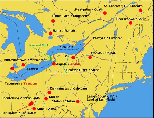
The Book of Mormon contains 345 names. The theory, proposed by Vernal Holley and posted by Mazeministries, is that 28 of these names were derived by Joseph Smith by looking at the names of places in the surrounding region, then altering the names slightly to create a map of Book of Mormon lands.
Rather than compare to "modern maps" and "modern place names" as Holley indicated that he did, we have made an attempt to locate these places on maps from the 1800s, which could have been available to Joseph Smith. When such a comparison is made, it becomes evident that Holley has included names of places which didn't even exist in Joseph Smith's time.
The following correspondences are listed. In order to obtain this list of parallels, a huge geographical area must be scanned: Five states and two Canadian provinces yield this list of parallels, and it gets even smaller when one actually tries to locate many of these places on a map. In the list below,
In the area indicated on the Holley map, modern maps show that there is a small, unincorporated community called Centerville, also known as Alma, in Tyler County, West Virginia, United States. Coordinates: 39°25′55″N 80°50′24″W. However, when we view the 1822 map of Virginia, we cannot find the name "Alma" anywhere.
"Antrim Township" is located in Franklin County, Pennsylvania. It was named after County Antrim in Northern Ireland. The township was organized in 1741.
The name "Anti-Anti" doesn't even appear in the Book of Mormon, nor does the biblical name "Antioch."
The name "Boaz" is from the Bible. Joseph would not have needed to look at a map for this one, unless one accepts Holley's assertion that the Holley map is supposed to show the geographical locations of Book of Mormon places.
The name "Comner" doesn't appear in the Book of Mormon. The name "Comnor" does, in Ether 14꞉28
. Of course, "Comnor" doesn't match "Conner" quite as closely in spelling. We cannot find "Connor" in either New York or Pennsylvania.
The actual name is "Saint-Éphrem-de-Beauce, Quebec." Wikipedia shows the town being established with that name in 1866. This is 36 years after the publication of the Book of Mormon. The Book of Mormon name "Ephraim," of course, is easily found in the Bible.
According to their website, Hellam Township, Pennsylvania, was established in 1739.
Jacobsburg, Belmont Co., Ohio does not even show up on a 1822 map of Ohio. According to Wikipedia: "Jacobsburg was laid out in 1815. It was probably named for its founder, Jacob Calvert." Therefore, the town definitely existed prior to the publication of the Book of Mormon, but was apparently too small to appear on the 1822 map seven years later. By 1833, three years after the publication of the Book of Mormon, Jacobsberg had grown to include "one tavern, two stores, a physician, sundry mechanics, and about 120 inhabitants." [1] Jacobsburg does indeed appear on an 1831 map of Ohio (one year after the Book of Mormon was published).
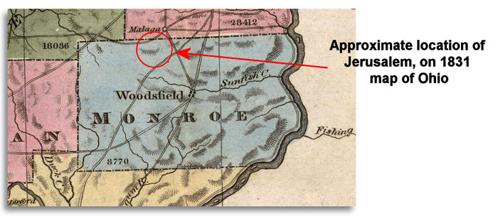
Jerusalem, Monroe Co., Ohio does not even show up on a 1822 map of Ohio, nor does it show up on a 1831 map of Ohio (one year after the Book of Mormon was published). Even today the village of Jerusalem occupies only 0.2 square miles. The Holley map shows "Jerusalem" in Ohio, but we went ahead and searched for other towns named "Jerusalem." It turns out that there is a Jerusalem, New York that was established in 1789, however, it does not appear on either the 1822 map or the 1831 maps of the state of New York. The town was named after the Biblical city of Jerusalem. Besides, the name "Jerusalem" is from the Bible. Joseph would not have needed to look at a map for this one, unless one accepts Holley's assertion that the Holley map is supposed to show the geographical locations of Book of Mormon places.

The village of Jordan, New York existed prior to 1819 and became an incorporated village in 1835. [3] The town of Jordan, New York was established prior to 1819, but does not appear on the 1822 map of New York. It does appear on the 1827 map (three years prior to the publication of the Book of Mormon) and the 1831 map of New York (one year after the publication of the Book of Mormon). The name "Jordan" is from the Bible. Joseph would not have needed to look at a map for this one, unless one accepts Holley's assertion that the Holley map is supposed to show the geographical locations of Book of Mormon places.
Vernal Holley states in his book Book of Mormon Authorship, that he relies upon "modern maps" when he speculates on the name Kishkumen,
The location of the Book of Mormon city of Kishkumen is not given in the text. However. there are names similar to Kishkumen, on modern maps, in the location of Spaulding's Manuscript Story setting. [4]
Kiskiminetas Township, Armstrong County, Pennsylvania was given that name in 1832, two years after the Book of Mormon was published. From History of Armstrong County Pennsylvania, written in 1883 by Robert Walter Smith, "The petition of sundry inhabitants of Allegheny township was presented December 22, 1831, to the court of quarter sessions of this county, asking that a new township be formed out of the upper end of Allegheny township, to be called Kiskiminetas. Philip Klingensmith, John Lafferty and John McKissen were appointed viewers, who, after one continuance of their order, presented their report recommending the organization of the new township, which was approved by the court June 19, 1832." off-site Kiskiminetas River in Pennsylvania does exist prior to the town, and one would assume that it would show up on a map. In addition, the name appears as a place name on page 40 of the 1776 publication A Topographical Description of Such Parts of North America as are Contained in the (Annexed) Map of the Middle British Colonies, &c. in North America, by T. Pownhall.[5]
There is indeed a "Lehigh Valley" located in Pennsylvania.
According to their website, Mantua Village, Ohio, was incorporated in 1898. This is 68 years after the publication of the Book of Mormon.
There is a town "Monroe, New York" which was named in 1808. The town does not appear on either the 1822 or the 1831 maps of New York.
According to the Minoa town website, the town of Minoa, New York received that name in 1895. That is 60 years after the Book of Mormon was published.
Moravian Indian Reserve No. 47, Ontario, appears to have been established in 1782.
According to Wikipedia, Morin Township, Quebec, was formed in 1852. This would be 22 years after the Book of Mormon was published.

The name "Noah" is from the Bible. Joseph would not have needed to look at a map for this one, unless one accepts Holley's assertion that the Holley map is supposed to show the geographical locations of Book of Mormon places.
See "Oneida Castle".
Oneida Castle, New York is located at 43°4′42″N 75°38′0″W. The town has existed since the 18th century.
We cannot find "Omer" on any modern map of Pennsylvania, New York or Canada.
Holley speculates that Joseph obtained the name "Rama" from the Rama Indian Reservation or Rama Township, noting that
"Today, south by southeast from Lake Superior (Waters of Ripliancum?), near Lake Simcoe in Ontario, Canada, is the Rama Indian Reservation, [61] located within the boundaries of Rama Township. [62] The Book of Mormon Ramah was [relatively near] the Waters of Ripliancum in the "land northward," and, similarly, the modern day Rama Indian Reservation is located [relatively near] several place names with a "Ripple" designation, in Canada (the north country)."[6]
However, the Rama Indian Reservation did not exist as such until 1836, when the Chippewas of Lake Simcoe and Huron were forced to move and purchased the land in Rama Township in 1836.
Known as the Chippewas of Lake Simcoe and Huron, our people are part of the Chippewa Tri-Council, an alliance of three First Nation communities now known as Beausoleil First Nation on Christian Island, the Chippewas of Georgina Island on Georgina Island, and Rama First Nation. Under the leadership of our hereditary Chief, Chief Musquakie(Yellowhead) who served his community from 1818 to 1844, the Chippewa Tri-Council First Nations continue their alliance today.
Well known for our hospitality, we shared our knowledge and medicines with early settlers which enabled them to survive their first difficult years in a sometimes harsh land.
Around 1830, our community was moved to the Coldwater Narrows area by the Crown, part of an “experiment” which shaped “Indian Reserves”. We continued on as industrious people, building a road for commerce which is known today as Highway 12, establishing farms, mills, and markets for selling produce, fish and game to settlers and travelers.
Forced to move again after our land was taken in what is now being termed an “illegal surrender”, we purchased land in Rama Township in 1836 and made a new beginning for our people. [7]
This is six years after the publication of the Book of Mormon. Moreover, the Rama Township, Ontario, itself was only "first surveyed in 1834." [8], four years after the publication of the Book of Mormon. [9]
Holley speculated that "Waters of Ripliancum may have been Lake Superior, the largest of the five Great Lakes. On or near the north shore of Lake Superior are Ripple Bay, Ripple Creek, Ripple Reef, and Ripple Lake -- names surprisingly similar to the "Waters of Ripliancum." [10] However, Ripple Lake is so small that it is difficult to locate on modern day maps, and it is one of more than 250,000 lakes in Ontario. Are we to assume that Joseph selected this one location amongst many, and then converted the name "Ripple Lake" to "Ripliancum?"
The name "Sodom," of course, is well known from the Bible. Joseph would not have needed to look at a map for this one, unless one accepts Holley's assertion that the Holley map is supposed to show the geographical locations of Book of Mormon places.
There is a Shiloh, Pennsylvania on modern maps, however, it is a Census Designated Place (CDP) consisting of 4.2 square miles [11] that was established only for statistical purposes. As such, it does not appear on any maps. The name "Shiloh" is a biblical name.
The name "Land of Midian" is from the Bible and it is located in Egypt. Joseph would not have needed to look at a map for this one, unless one accepts Holley's assertion that the Holley map is supposed to show the geographical locations of Book of Mormon places. We are unable to locate a "Midian" or "Land of Midian" on any modern map of Pennsylvania.
Notes

FAIR is a non-profit organization dedicated to providing well-documented answers to criticisms of the doctrine, practice, and history of The Church of Jesus Christ of Latter-day Saints.
We are a volunteer organization. We invite you to give back.
Donate Now